Who we are
INTERNATIONAL EXPERTS.
We are experts with a broad multinational experience who are going to understand your problems and provide you with the solution you need, as you need ie, when you need it.
MISION.
We solve our clients problems.
Cur clients give us a task and they get a solution on time, on budget and fulfilling all agreed expectations.
VISION.
With more than 20 years experience in marine geo sciences projects in more than 20 countries around the world, working with different international companies within multidisciplinary group, we support our clients’ projects at any level! From feasibility to delivery.
Lets us know what you problem is: need of partners, lack of specific competences or anything else.
We find the right solution for you!
VALUES.
We praise our clients. We treat them as we would like to be treated when we have a problem and need to trust someone to help us.
We base all our commercial relation in the same standard principle:
COMMUNICATION, RESPECT & TRUST
What we do.
FOCUS ON YOUR CORE, MINIMIZE YOUR RISK.
We want our clients to focus on their core competences while we apply our competences to cover for their necessities.
We understand that geo sciences represents a small part of a marine project but we know that is one of the foundation in which the project supports.
If you want to minimise your economic risk, we offer you the most cost effective solution: Top quality for the time you need with total confidentiality.
CONSULT.
We find answers and technically robust solution for these problems which are out of your core competences but you require them to be treated with the highest level of care.
SUPPORT.
If you need support on our core competences we can also join your team and blend our experience, becoming part of your structure while you need us.
Experience.
PROJECTS.
Site surveys (2D HR seismics & gravity coring) to assess the existence of gasFreeRadikal2020-01-05T18:23:58+01:00

Development of a risk assessment procedure for 3D seismics jobs at tendering phaseFreeRadikal2020-01-05T17:59:50+01:00
Bathy LiDAR survey. Sectors (1500Km2 aprox.) of the eastern part of the Mexican Gulf coast (USA)FreeRadikal2020-01-05T17:48:02+01:00
Bathymetric LiDAR survey. Sectors (750Km2 aprox.) of the coast of Brittany (France)FreeRadikal2020-01-05T17:43:11+01:00
Exploration of gas hydrates offshore Constanta (Black Sea, Romania)FreeRadikal2020-01-05T17:34:09+01:00

Rheology of cohesive sediment in relation to nautical depth & dredgingFreeRadikal2020-01-05T17:00:25+01:00
Cable routes survey for new round (8 developments) of offshore wind farms in Danish waters.FreeRadikal2020-01-05T17:37:30+01:00
Optimisation of the sediment management activities and implementation of a nautical depth procedure for the Port of Cochin (India)FreeRadikal2020-01-05T16:56:00+01:00
Naskov harbour and access channel high resolution mapping (Denmark)FreeRadikal2020-01-05T17:54:41+01:00
Clients.
WE HAVE SUCCESSFULLY WORKED IN PROJECTS FOR:
Team.
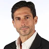
FAUSTINO (TINO) MANSO
Based on a solid academic background (MSc, PhD) and a broad professional experience, I have managed successfully people (multinational and multidisciplinary teams), processes and projects in different geographic areas.
I blend academic knowledge, more than 20 years of experience and all the tools acquired during my MBA to adapt to any condition and tackle the most complicated issues achieving the planned goals; at the expected time, within budget and with the contractually agreed quality.
I am used to being the link between the organization I work with and a third party, managing this relation to find suitable win-win scenarios in minimum time.
I like taking an active role and commit to the common objectives. I am a task oriented person focused on maximizing results and applying innovative solutions to achieve the required results on a cost effective way, within schedule; while seeking constantly for sources of competitive advantage.